Application Information
Licensing of Private Remote Sensing Space Systems
PRA-Application Guide
License Application
OMB: 0648-0174
OMB Control Number: 0648-0174
Expiration Date: XX/XX/20XX
CUI//PRIVACY/PROPIN//FEDCON
when filled in
Applicant Exempt from CUI Handling and Dissemination Restrictions


UNITED
STATES DEPARTMENT OF COMMERCE
National
Oceanic and Atmospheric Administration
Office
of Space Commerce
Commercial Remote Sensing Regulatory Affairs
Division
Washington, D.C. 20230
Application Information
Instructions
This form may be filled out in multiple formats, including by email in Word document format by replacing blue guidance text with your responses using blue text or by filling out an electronic conditional form. If responding by Word document:
Please remove all guidance text prior to submission.
Sections or questions that are marked optional are questions that have been identified as commonly asked to clarify responses to required questions on a case-by-case basis to ensure completeness.
If you wish to submit the application in Word document format through encrypted communications, please email crsra@noaa.gov for instructions.
Any questions regarding this form should be directed to crsra@noaa.gov.
Privacy Act Statement
PRIVACY ACT STATEMENT: The authorities for the collection of the following information and the intended uses of the information are detailed online at the following link: CRSRA Privacy Act Statement 2024. You may request a copy of the linked Privacy Act Statement by emailing crsra@noaa.gov.
Confirmation of having read the Privacy Act Statement is required.
Requisite Application Information
To apply for a license to operate a remote sensing space system under 51 U.S.C § 60101, et seq. and 15 C.F.R. Part 960, you must provide fully accurate and responsive information to the prompts required by the regulation. If any information you submit later becomes inaccurate or incomplete before a license grant or denial, you must promptly contact the Secretary and submit correct and updated information as instructed by the Secretary. If a license is granted, the responses will be incorporated into the license as material facts, consistent with the License Template found at 15 C.F.R. Appendix C to Subpart E of Part 960.
Confirmation of having read the Application Information Required statement is required.
Application Continues on Next Page
Part A: Operator Information Review and Provision of Additional Information
A.1. Operator Information Review
If this information is held on file through an account or other means, confirmation of the accuracy of the information will be required, or edits can be made as needed. If this information is not otherwise available, the following information is required at this point:
a. Operator name:
Please use the registered business name. Please also include any and all colloquial names, doing business as names, acronyms, or other common names.
b. Operator address:
This must be a physical address, not a P.O. Box.
For businesses, organizations, etc.: Applicant’s physical address of the principal place of business or headquarters
For individuals: Applicant’s home address or reliable address for professional correspondence (not a P.O. Box)
c. Operator general phone number:
For businesses or universities, this is not the same as provided for the points of contact in "d." below; for individuals, this might be the same contact as listed in “d.” below.
d. Operator general email address:
For businesses or universities, this is not the same as provided the points of contact in "d." below; for individuals, this might be the same contact as listed in “d.” below.
e. Place of incorporation or charter
Please provide the state in which the business entity is incorporated or the academic institution is chartered.
A.2. Authorized Point of Contact Information Review
If this information is held on file through an account or other means, confirmation of the accuracy of the information will be required, or edits can be made as needed. If this information is not otherwise available, the following information is required at this point:
a. Authorized individual’s name:
b. Authorized individual’s work title: (optional)
c. Authorized individual’s email address:
d. Authorized individual’s phone number:
e. Authorized individual’s principal address of business, if different from Operator’s address:
f. For each authorized individual added, 2a – 2e will be requested. (conditional)
A.3. Limited Operations Directive Point of Contact
If this information has been provided in the Operator Information Form and is the same for all licenses held by the Operator, this information will be provided for review and confirmation, but does not need to be entered a second time.
These points of contact should be knowledgeable representatives with authority to direct the operations of the System and who will be available at all times to respond to a limited-operations directive, such as a senior engineer, permanent faculty (not student), or external personnel that possess authorization to control the System. At a minimum, two different individuals, or an individual and a response team distribution list and common phone number monitored by a group of personnel, such as an operations team, is required.
a. Limited operations point of contact name:
b. Limited operations point of contact work title:
c. Limited operations point of contact phone number:
d. Limited operations point of contact email address:
e. Alternative limited operations point of contact: (conditional/optional)
i. Alternative limited operations point of contact name:
ii. Alternative limited operations point of contact work title:
iii. Alternative limited operations point of contact phone number:
iv. Alternative limited operations point of contact email address:
f. Response team contact: (conditional/optional)
i. Response team phone number:
ii. Response team email address:
A.4. Ownership Interests in the Operator
This set of questions will be asked upon an Operator opening an application for a new system license. For operators holding multiple licenses, the information will be stored and confirmation of the information accuracy or revisions, if inaccurate, will be required.
a. Does the Operator have majority U.S. ownership?
Yes/No
Provide percentage U.S. ownership on a fully diluted basis.
b. If the answer to A.3.a. is “yes,” report any domestic entity or individual with an ownership interest in the Operator totaling at least 50 percent:
For each entity, provide the name (individual, business, etc.), the address, and the percentage of ownership on a fully diluted basis.
c. If the answer to A.3.a. is “no,” report all foreign entities or individuals whose ownership interest in the Operator is at least 10 percent:
For each entity, provide the name (individual, business, etc.), the address, and the percentage of ownership on a fully diluted basis.
d. Report any ownership interest in the Operator by any foreign entity or individual on the Department of Commerce’s Bureau of Industry and Security’s Denied Persons List or Entity List or on the Department of the Treasury’s Office of Foreign Asset Control’s Specially Designated Nationals and Blocked Person List:
Relevant Department of Commerce1 and Department of Treasury2 lists are publicly available.
Attestation for no ownership interest by listed entities:
□ I certify that no foreign entities or individuals on the Department of Commerce’s Bureau of Industry and Security’s Denied Persons List or Entity List or on the Department of the Treasury’s Office of Foreign Asset Control’s Specially Designated Nationals and Blocked Person List holds ownership interest in the operator identified in Part A.1. of this application.
Attestation for ownership interest by listed entities:
□ I certify that foreign entities or individuals on the Department of Commerce’s Bureau of Industry and Security’s Denied Persons List or Entity List or on the Department of the Treasury’s Office of Foreign Asset Control’s Specially Designated Nationals and Blocked Person List holds ownership interest in the operator identified in Part A.1. of this application, and those entities are: [insert name of entity(ies) here].
If attesting to ownership by denied parties, please also provide the percentage of ownership that each denied party holds.
A.5. Identity of any subsidiaries and affiliates playing a role in the operation of the System, including a brief description of that role:
Operators should identify any person or entity that both plays a role in the operation of the system and is controlled by the applicant, controls the applicant, or is in common control with the applicant, as defined in CRSRA Guidance Circular 960.16-1.3 Other entities that will play a role in the operation of the System, such as contractors, should be identified in Part B, not here; entities listed here may also need to be disclosed in Part B.
Application Continues on Next Page
Part B: General Mission Information
B.1. System Names and Designators
a. System name:
This is the official name of the system as it will be designated in the license. This should be the same as the name used for other licenses (FCC, FAA, etc.), the common name that is or will be used in registration, and the primary name when contracting launch services.
b. Alternative system name(s): (conditional/optional)
This should include all other payload names, including: acronyms, press release names, different names used in prior filings with the Department of Commerce (for example, on an initial contact form), and other designators given to the system by other U.S. Government agencies (e.g., the FCC call sign).
c. Internal designator or designator format: (optional)
Provide how the system names will be internally kept and referenced (i.e., the “tail number” format and numbering scheme) by the operator.
d. Is this system a hosted payload on board a deployed spacecraft, a single spacecraft, multiple spacecraft within a multi-generational or multi-capability constellation, or a full constellation of identical spacecraft (more than one spacecraft)? (optional)
Hosted payload/single satellite/multiple spacecraft within constellation/ full constellation?
e. If this system refers to a hosted payload on board a deployed spacecraft, specify the following:
i. Host system name: (required)
ii. Host system alternative name(s): (optional)
iii. Host system alternative designator(s): (optional)
NOTE: Information pertaining to the host system operator will be provided in Part B.4.
f. If this system is a part of a larger constellation, how many spacecraft comprise the larger constellation? (optional)
Numeric response
B.2. Other Licensing Authorities (optional)
a. Is the operator applying for any licenses for operations of the system from other agencies of the U.S. Government?
Please list other U.S. licenses the system will operate under the agencies holding those licenses.
b. Is the operator applying for any licenses for the operations of the system to be granted by governmental authorities other than the United States?
Please include details such as which government such licenses will be/have been granted from, the agency/bureau/commission granting the license, and if the licenses have been applied-for or issued.
B.3. Brief Mission Description
The questions asked in this section may vary based upon response to B.1.e.
a. Provide a narrative description of the system’s mission purpose and operations.
What activity is the payload/satellite/constellation being used for?
How will the remote sensing data be used?
Is the mission technology development/demonstration or commercial use
If for commercial use, what is the commercial use?
What are the on-board mission payloads? (e.g., communications, remote sensing, compute payloads, etc.)
Will the system image artificial resident space objects (ARSO) and with which sensor(s)?4
B.4. Detailed Mission Description (optional)
a. Will the system perform rendezvous, proximity operations, or docking with one or more other artificial resident space objects (ARSOs)?
Yes/no
Provide a narrative statement of the type of operations and purpose of such operations if “yes”
b. Nominal orbital residence time
Assuming nominal operations and adherence to the system’s disposal plan, specify the anticipated time from on orbit deployment of each system component through successful disposal. For constellations, provide the anticipated residence time of each on orbit component of the system.
c. Off-nominal orbital residence time
Assuming anomalous operations or loss of mission, specify the anticipated time from on orbit deployment of each system component through unaided disposal through natural causes. If the system will be in an orbit in which disposal through natural causes is not plausible, respond “N/A.”
d. What is the disposal method for the on orbit components of the system?
Examples: move to graveyard orbit, natural decay with no propulsive maneuver, propulsive maneuver to expedite deorbit, third-party assisted deorbit, on orbit salvage, other (describe)
e. Assuming nominal operations, what steps will be taken to dispose of the on orbit components of the system?
Textual description including steps to maneuver the system, passivate the system, and ultimately dispose of the system. If no deliberate steps will be taken to prepare the system for decay into the atmosphere, state “None.”
f. Assuming nominal operations, how long will disposal of on orbit components of the system take following declaration of end-of-mission?
Time in days/months/years
B.5. System Participants: Ownership, Management, and/or Control by Third Parties
1. If any entity or individual other than the operator will own, control, or manage any spacecraft in the System
PLEASE NOTE:
The below prompts are referring only to the spacecraft listed in Part C, not to any individual payload.
Provide information in the prompts below for any entities other than the operator who will own, control, or manage any of the spacecraft listed in Part C.
These entities may include subsidiaries or affiliates or third parties contracted for satellite control and management services.
a. System participant identity and contact information:
i. Entity name:
ii. Entity general physical address:
iii. Entity general email address:
iv. Entity general phone number:
b. Individual(s) representing the system participant and serving as point of contact with the Department of Commerce:
i. Individual’s name:
ii. Individual’s work title:
iii. Individual’s work address:
iv. Individual’s email address:
v. Individual’s phone number:
c. System participant nationality:
Provide the nationality of the system participant (country of incorporation, charter, or citizenship).
d. Relationship to operator (e.g., executing the operator’s instructions or advising the operator’s course of action under a contract):
Provide a response that states the operator’s relationship with each system participant and what role the system participant will perform in owning, managing, and/or controlling the spacecraft.
2. If any entity or individual other than the Applicant will own, control, or manage any remote sensing instrument in the System:
PLEASE NOTE:
These prompts are referring to the individual remote sensing instruments only, not to an entire spacecraft.
Provide information in the prompts below for any entities other than the operator who will own, control, or manage any of the remote sensing instruments listed in Part E.
a. System participant identity and contact information:
i. Entity name:
ii. Entity general physical address:
iii. Entity general email address:
iv. Entity general phone number:
b. Individual(s) representing the system participant and serving as point of contact with the Department of Commerce:
i. Individual’s name:
ii. Individual’s work title:
iii. Individual’s work address:
iv. Individual’s email address:
v. Individual’s phone number:
c. System participant nationality:
Provide the nationality of the system participant (country of incorporation, charter, or citizenship).
d. Relationship to operator (e.g., executing the operator’s instructions or advising the operator’s course of action under a contract):
Provide a response that states the operator’s relationship with each system participant and what role the system participant will perform in owning, managing, and/or controlling the remote sensing instrument.
3. If any entity or individual other than the Applicant will own, control, or manage any mission control center(s) with the ability to operate the System
These prompts are referring to the mission control centers listed in Part F, not to the spacecraft, instruments, or the system as a whole.
Provide information in the prompts below for any entities other than the operator who will own, control, or manage any of the mission control centers, subsidiary mission control center, or backup mission control centers listed in Part F.
a. System participant identity and contact information:
i. Entity name:
ii. Entity general physical address:
iii. Entity general email address:
iv. Entity general phone number:
b. Individual(s) representing the system participant and serving as point of contact with the Department of Commerce:
i. Individual’s name:
ii. Individual’s work title:
iii. Individual’s work address:
iv. Individual’s email address:
v. Individual’s phone number:
c. System participant nationality:
d. Relationship to operator (e.g., executing the operator’s instructions or advising the operator’s course of action under a contract):
Provide a response that states the operator’s relationship with each system participant and what role the system participant will perform in owning, managing, and/or controlling the mission control center.
Application continues on next page
C. Description of Spacecraft Upon Which the Remote Sensing Instrument(s) is (are) Carried
PLEASE NOTE:
These prompts are referring to the satellite that hosts the payload and deploys from the space launch vehicle, not the space launch vehicle itself.
C.1. Description of Spacecraft
a. Total number of spacecraft to be launched under this license:
Numeric answer
b. Number of spacecraft under this license on orbit at any one time:
Numeric answer
c. For each spacecraft, estimated launch date in calendar quarter or actual launch date:
d. Spacecraft identifier(s): (optional)
The NORAD ID(s) of each on orbit component of the system, and the international code of each on orbit component of the system.
NOTE: If the system has no components on orbit at the time of application, this information is not required. The information will be requested during annual the license review following launch of each on orbit component of the system and assignment of such alternative designators.
e. Are all spacecraft under this license identical in physical dimensions, mass, composition, encryption architecture, and propulsive capability?
Yes/No
f. If no to the question above, how many unique spacecraft configurations are there?
Numeric answer
g. For each spacecraft configuration, provide: physical dimensions (minimum and maximum in three dimensions, meters), mass (minimum and maximum, kilograms), and composition.
C.2. Propulsion & Attitude Control
a. Does the system have propulsion?
Yes/no
b. Provide details regarding the propulsion design, capability, and how it will be used.
c. Ability of the spacecraft to slew, point, or digitally look off-axis from the x, y, and z axes of travel including maximum range (in degrees), rate (in degrees per second), and settle time (seconds):
This prompt is referring to the movement of the spacecraft as a whole, not to the movement of any individual instrument.
Assume that the z-axis is oriented in the nadir direction, the x-axis is oriented in the direction of travel, and the y-axis is perpendicular to both z and x in the right-hand sense.
C.3 Affirmation of Positive Control
The following questions are applicable if the system has propulsion and the answer to C.2.a is yes.
a. Confirm that there will be, at all times, measures in place to ensure positive control of any spacecraft in the system that have propulsion. Such measures include encryption of telemetry, command, and control communications or alternative measures consistent with industry best practice.
□ The applicant affirms that there will be, at all times, measures in place to ensure positive control of any spacecraft in the system that have propulsion.
b. Does the system employ encryption on communications to and from the spacecraft?
Yes/no
c. What standard of encryption and level of encryption is employed?
d. Does the system employ encryption on remote sensing mission data?
Yes/no
e. What standard of encryption and level of encryption is employed?
f. Provide a description of all measures in place to assure positive control, as well as the standards and/or best practices employed to select and implement those measures.
D. Orbital Characteristics of the System
a. How many different orbital configurations (planes and altitude ranges) will be employed for nominal mission operations?
If multiple planes and/or planes and altitudes will be employed, all information requested below will need to be provided for each configuration.
b. Satellite deploy orbit:
i. Minimum altitude (km)
When calculating altitude above Earth’s surface from your orbital elements, CRSRA recommends using a value of 6,378 km for the Earth’s radius.
ii. Maximum altitude (km)
iii. Minimum eccentricity
iv. Maximum eccentricity
v. Minimum inclination (degrees)
Response in degrees
vi. Maximum inclination (degrees)
vii. Period (minutes)
Response in minutes
viii. Longitude of the ascending node (degrees)
Provide the expected longitude (in degrees) from the vernal equinox (J2000) to the ascending node (northbound equatorial crossing) for each spacecraft listed in Part B section 4.a. at the date corresponding to the spacecraft's epoch. Spacecraft that are in the same orbit can be grouped together. If there are multiple orbital planes, please indicate the separation(s) of adjacent ascending nodes (J2000) and also include the longitude of the ascending node from the vernal equinox (J2000) at epoch of at least one spacecraft in each plane.
PLEASE NOTE:
If the orbit is equatorial, please indicate so and enter a value of zero for the longitude of the ascending node with respect to the vernal equinox (J2000).
If the orbit is GEO, please indicate so and additionally provide the eastward angle (in degrees) from the Prime Meridian of its ascending node (i.e., the geographic longitude of the ascending node).
If the orbit is sun-synchronous, please indicate so and additionally provide the local time of the ascending node (LTAN).
If the longitude of the ascending node with respect to the vernal equinox (J2000) will precess, please indicate the rate of precession (in degrees/day) and the direction in which the node will precess (E or W).
ix. Argument of perigee
Provide the expected angle (in degrees) measured from the longitude of the ascending node (with respect to the vernal equinox) to the perigee point along the satellite's direction of travel for each spacecraft listed in Part B section 4.a. at the date corresponding to the spacecraft's epoch. Spacecraft that are in the same orbit can be grouped together. If multiple spacecraft are in the same orbit plane, please indicate their mean anomaly separation(s) and also include the mean anomaly at epoch of at least one spacecraft in the plane, if known.
PLEASE NOTE:
If the orbit is circular (i.e., the orbit has no perigee), you may enter zero. For the purposes of this application, you may report a circular orbit if your eccentricity is less than 0.001 (rounded to three significant figures).
If the orbit is equatorial (i.e., the orbit has no ascending node), then the angle is measured as the longitude of perigee with respect to the vernal equinox (J2000).
Please indicate the rate and direction at which the argument of perigee will precess (in degrees/day). If the orbit is circular, then you may enter zero.
c. Will the satellite deploy into its mission orbit? (optional)
Yes/No
d. Estimated time to reach mission orbit (optional)
Time in hours/days/months
e. Method for reaching mission orbit (optional)
For example, natural decay, orbital transfer vehicle, propulsive maneuver
f. Mission orbit
i. Minimum altitude (km)
ii. Maximum altitude (km)
iii. Minimum eccentricity
iv. Maximum eccentricity
v. Minimum inclination (degrees)
vi. Maximum inclination (degrees)
vii. Period (minutes)
viii. Longitude of the ascending node (degrees)
ix. Argument of perigee
x. True/mean anomaly for spacecraft in the same orbital plane
g. How many spacecraft will be deployed in each orbital configuration?
Numeric response associating a number of spacecraft with each unique orbital configuration provided above
h. Lowest altitude at which system can be operated
Refers to the lowest altitude at which the operator is capable of maintaining decision-making authority over the functioning of the system.
Application continues on next page
E. Remote Sensing Instrument(s) Parameters:
You will be required to identify each remote sensing instrument by quantity and type in the system. Please see the definition of “remote sensing” at 15 C.F.R. § 960.4 to determine which instruments need to be listed here. Do not include any instruments that will be used primarily for mission assurance as defined in CRSRA Guidance Circular 960.2-1.5 Please contact crsra@noaa.gov if you are uncertain whether you should include an instrument or not.
Provide the information below for each and every remote sensing instrument in the system.
a. How many of each of the following remote sensing instruments are present in the system: Electro-optical, Interferometer, Radiometer, Synthetic Aperture Radar (SAR), Light Detection and Ranging (LIDAR), GNSS-Reflectometry (GNSS-R), Other (Define)
If Other, please provide a complete textual description of the phenomenology and sensor type for which you are seeking a license.
E.1. Information Applicable to Electro-Optical Instruments.
Responses must include the calculations used to derive the reported parameters.
Operators must complete this section for each unique electro-optical instrument
Not all questions may apply.
a. How many identical electro-optical instruments with the below parameters are present in the system?
b. Textual description of electro-optical sensor wavelength:
Visible and Near Infrared (VNIR): 380 – 1,200 nm
Short Wave Infrared (SWIR): 1,200 – 3,000 nm
Mid-Wave Infrared (MWIR): 3,000 – 8,000 nm
Long Wave Infrared (LWIR): 8,000 – 14,000+ nm
c. Textual description of electro-optical band configuration:
Panchromatic: An instrument producing a single-band, greyscale image that is formed by the collection of all detected energy for some range of visible wavelengths, or by the combination of such energy after collection such that information from distinct wavelengths cannot be recovered from the preprocessed image product.
Multispectral Imager (MSI): An instrument collecting energy in 2 – 30 spectral channels that remain separated after collection.
Hyperspectral Imager (HSI): A hyperspectral imaging system or data set is defined as one in which pixel spectra are measured over a spectral range without gaps and with a maximum spectral sampling interval not exceeding 1/30 of the spectral range.
Interferometer: An instrument employing reflective optics to generate interferograms for conversion into spectral response curves with ultra-high spectral sampling.
Other (Describe)
d. Is this a commercial-off-the-shelf sensor or a custom sensor (focal plane array)? (optional)
Commercial-off-the-shelf/custom
(If COTS) Make
(If COTS) Model
(If COTS) Provide data sheet
e. Is this a commercial-off-the-shelf lens or optical assembly or a custom lens or optical assembly? (optional)
Commercial-off-the-shelf/custom
(If COTS) Make
(If COTS) Model
(If COTS) Provide data sheet
f. Total number of spectral bands:
Numeric response
g. Configuration of spectral bands able to be collected at one time:
E.g., PAN only, PAN and MSI, PAN and HSI, HSI only
h. Number of spectral bands able to be collected at one time:
Numeric response
i. Spectral range of each band (full spectral response range, nm; full width half maximum spectral response range, nanometers; spectral response curve or provide data to generate curve):
Full Width (rounded to nearest 1% of maximum amplitude) of each band
Full Width Half Maximum (FWHM) of each band
NOTE: If the remote sensing instrument has available a spectral response curve or graph, please include the graph or the data used to generate the graph.
j. Wavenumber resolution (if interferometer) (conditional/optional)
k. Is this a line scan imager or an aerial/snapshot imager?
l. Time delay integration:
i. Minimum value
ii. Maximum value
iii. Increments
Must be provided for each imaging mode for which the values are unique.
m. Imaging rate:
i. Minimum
ii. Maximum
Report values in frames per second (FPS) for area/snapshot sensors, line scan rate in hertz for line scan sensors. Provide lines per second for each TDI mode, as denoted in prior question, if applicable.
n. Pixel pitch
Provide response in meters
o. Focal length
Provide response in meters
p. Aperture diameter (optional)
Provide response in meters
q. Earth-viewing estimated collection area in kilometers squared per unit time per electro-optical remote sensing instrument specified in Sections E.a. and E.1.a-b.
i. How is this value being estimated?
This value may be calculated, see E.1.q.iii below OR
This value may be simulated by operator models, see E.1.q.ii below OR
This value may be estimated or based upon from actual collection volumes achieved by on orbit spacecraft
ii. If simulated, please provide attachments demonstrating the results
iii. If calculated, please use the calculations the below, providing the value of each variable with units:
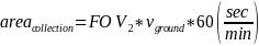
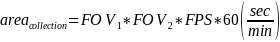
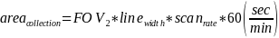
The equations provided below are meant to provide a means of computing the collection swath of the remote sensing instrument in a one-minute time period. The following equations assume a nadir-pointing sensor without any pointing/slewing over the course of imaging; verify that this assumption is appropriate for the operator’s system.
For a snapshot sensor, use the general form of the equations below to calculate collection area:
First, evaluate whether

Where:
 is the field of view in the along-track dimension at the maximum
operating altitude (in km)
is the field of view in the along-track dimension at the maximum
operating altitude (in km) is the ground track velocity of the sensor at its maximum operating
altitude (km/s)
is the ground track velocity of the sensor at its maximum operating
altitude (km/s) is the rate at which the remote sensing instrument can collect
imagery (in frames per second)
is the rate at which the remote sensing instrument can collect
imagery (in frames per second)
In other words, if subsequent frames have overlap we only wish to know the area being imaged on the ground in aggregate – not the area for each individual frame. Therefore, a simplified collection area equation should be used, as follows:
Where:
 is the field of view in the cross-track dimension at the maximum
operating altitude (in km)
is the field of view in the cross-track dimension at the maximum
operating altitude (in km)-
is the ground track velocity of the sensor at its maximum operating
altitude (km/s)
However, if

Meaning subsequent frames image different swaths on the surface of the Earth, then please use the following:
For a line-scanning sensor, if the sensor collects overlapping or continuous swaths of data, showing your work, use the general form of the equations below to calculate collection area:
If the sensor does not collect continuous or overlapping swaths of imagery, please use the following equation:
Where:
 is the along-track width of a single line (km)
 is the rate at which lines are scanned (in lines/sec)
r. Noise Equivalent Target ( )6
and Noise Equivalent Spectral Radiance (
)6
and Noise Equivalent Spectral Radiance ( )7.
Operators must complete this section for each band for which the
ground sample distance (GSD) of the system is 5 meters or less. NET
is the primary parameter used by the U.S. Government to describe an
Electro Optical sensor’s light sensitivity performance for a
target at the same distance from the sensor as is specified as the
minimum operating altitude. If NET or
NESR cannot be calculated, report the expected minimum detectable
ground target radiance in watts.
)7.
Operators must complete this section for each band for which the
ground sample distance (GSD) of the system is 5 meters or less. NET
is the primary parameter used by the U.S. Government to describe an
Electro Optical sensor’s light sensitivity performance for a
target at the same distance from the sensor as is specified as the
minimum operating altitude. If NET or
NESR cannot be calculated, report the expected minimum detectable
ground target radiance in watts.
i. Range to target at nadir (R, meters)
Use the lowest altitude at which the system can be operated
ii. Planck’s constant (h, m2 kg/s).
Use 6.62607015×10⁻³⁴
iii. Speed of light (c, m/s).
Use 299,792,458
iv. Total system read noise per frame ( , e-)
, e-)
v. Band center wavelength ( ,
m)
,
m)
vi. Effective aperture area ( m2)
m2)
vii. System transmittance average over band ( unitless)
viii. Integration time ( s)
s)
ix. Quantum efficiency average over band ( , e-/ph)
x. F-number (f#, unitless)
xi. Linear dimension of a focal plane pixel ( m)
m)
xii. Number of frame co-adds ( ,
unitless)
,
unitless)
xiii. Change in wavelength (bandwidth) of a band ( ,
m)
,
m)
xiv. Upward atmospheric transmittance ( ,
unitless)
,
unitless)
xv. Pixel area ( ,
m2)
,
m2)
xvi. Integration time ( ,
s)
,
s)
Please clearly provide the values for each variable in the equation. NOTE: Both metrics should be calculated for each band in the remote sensing system.

s. Information Applicable to Mid-Wave Infrared (MWIR) and Long Wave Infrared (LWIR). MWIR and LWIR are defined (in aggregate) as collecting in the spectral range of 3.0–14.0+ micrometers. Applicants must complete this section only if the response in Part B section 6.a. is “MWIR” or “LWIR”.
i. Estimated relative thermometric accuracy in degrees Kelvin (+/-
 degrees of actual):
ii. Noise Equivalent Differential Temperature (NEDT), or if NEDT cannot be calculated, simply provide the expected temperature sensitivity in terms of minimum resolvable temperature difference in degrees:
Provide a response (in milliKelvins) for each TIR sensor listed in Part B section 6.a.
NEDT (noise equivalent differential temperature) is the key figure of merit which is used to qualify midwave (MWIR) and longwave (LWIR) infrared cameras. It is a signal-to-noise figure which represents the temperature difference which would produce a signal equal to the camera’s temporal noise. It therefore represents approximately the minimum temperature difference which the camera can resolve. It is calculated by dividing the temporal noise by the response per degree (responsivity) and is usually expressed in units of milliKelvins. The value is a function of the camera’s f/number, its integration time, and the imaging scene temperature at which the measurement is made. Please provide each value.
If NEDT cannot be calculated, explain why not and report the expected temperature sensitivity in terms of minimum resolvable temperature difference (in milliKelvins).
t. Horizontal accuracy (meters, CE90):
u. Ability of the remote sensing instrument to slew, point, or digitally look off-axis from the x, y, and z axes of travel including:
i. mechanism (e.g., gimbal, phased array beam steering, pointing mirror assembly, etc.)
ii. maximum range (in degrees)
iii. rate (in degrees per second)
This prompt is referring to the movement of each instrument or any of its components independently to change the field of view of the instrument, not the movement of the entire spacecraft.
Assume that the positive z-axis is oriented in the nadir direction, the positive x-axis is oriented in the direction of travel, and the y-axis is perpendicular to both z and x in a “righthand” sense.
E.2. Information Applicable to Remote Sensing Light Detection and Ranging (LIDAR).
Responses relying on calculations must include the calculations used to derive the reported parameters.
Operators must complete this section for each unique LIDAR instrument.
The questions below pertain to the LIDAR head (active component); please complete Section E.1 to provide information pertaining to the receive optics and sensor(s)
a. How many identical LIDAR instruments with the below parameters are present in the system?
b. LIDAR type:
Linear scanning
Flash/Gieger
c. LIDAR subtype:
Elastic backscatter: pulse timing style remote sensing;
Differential absorption (DIAL): Using two closely spaced absorption wavelengths for known chemical (gas) species for concentration measurements;
Raman: Traditionally used for atmospheric temperature profiles;
Fluorescence: Measuring chemical species concentrations where the wavelength is tuned to specific spectral transition modes in specific chemical species; and
Doppler: measurement of phase due to relative motion of backscatter.
d. Waveform description:
e. Laser wavelength (nm):
f. Pulse frequency (kHz):
g. Full-width half-maximum laser pulse width (nanoseconds):
h. Full-width half-maximum spectral linewidth (nanometers):
i. Elevation (“Z”) accuracy (meters, LE90):
j. Horizontal accuracy (meters, CE90):
k. Collection volume (km2/min):
Calculation and variables required.
l. Ability of the remote sensing instrument to slew, point, or digitally look off-axis from the x, y, and z axes of travel including:
i. mechanism (e.g., gimbal, phased array beam steering, pointing mirror assembly, etc.)
ii. maximum range (in degrees)
iii. rate (in degrees per second)
E.3. Information Applicable to Synthetic Aperture Radar (SAR).
Responses must include the calculations used to derive the reported parameters.
Operators must complete this section for each unique SAR instrument.
a. How many identical SAR instruments with the below parameters are present in the system?
b. Textual description of SAR sensor:
S-Band: 3.1–3.3 GHz
X-Band: 9.2–10.4 GHz
C-Band: 5.25–5.57 GHz
L-Band: 1.215–1.30 GHz
Other (Describe)
c. Collection configuration:
Monostatic
Bistatic
Multistatic
d. Bistatic/multistatic configuration of the satellites: (conditional)
Bistatic/multistatic
e. Dedicated or opportunistic bistatic/multistatic collections: (conditional/optional)
Dedicated/opportunistic
f. Moving Target Indicator (MTI) collection (optional)
Please include whether your system is capable of performing Moving Target Indicator (MTI) collection mode(s), and whether MTI can be collected by a single monostatic satellite (utilizing multiple beams or apertures) and/or by multiple bistatic/multistatic satellites.
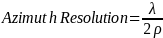
g. Azimuth resolution (ground plane, meters):
i. Transmit frequency center wavelength (λ , m)
ii. Lowest altitude at which capable of operating (km)
iii. Maximum dwell time (s)
iv. Aspect angle, calculated using lowest altitude, maximum dwell time, and maximum grazing angle from E.3.q (ρ, radians)
Provide a response for each SAR sensor listed in Part E.3. using the formula below (you must list each variable, each assumption, and show all calculations) for the peak-to-null azimuth resolution.
h. Range resolution (ground plane, meters):
i.
Speed of light ( ,
m/s)
,
m/s)
Use 299,792,458
ii. Maximum pulse bandwidth ( ,
Hz)
,
Hz)
iii. Minimum grazing angle from E.3.q ( ,
degrees)
,
degrees)
Provide a response for each SAR sensor listed in Part B section 6.a. using the formula below (you must show your calculations) for the peak-to-null range resolution. This should represent your best resolution capability (i.e., your maximum transmittable RF bandwidth).

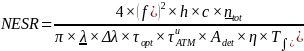
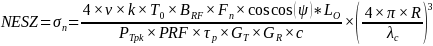
i. SAR Signal-To-Noise Ratio (SNR):
Provide a response for each SAR sensor listed in Part B section 6.a. using the formula below (you must define each variable, list all used assumptions, and show your calculations).
Average transmitted power (PT, Watts)
Satellite velocity (v, m/s)
Boltzmann’s Constant (k, Joules per Kelvin)
Use 1.38 x 10⁻²³
Standard noise temperature (
 ,
Kelvin)
,
Kelvin)Transmitted RF Bandwidth (
 ,
Hz)
,
Hz)Receiver noise factor (
 ,
unitless)
,
unitless)Graze angle (
 ,
degrees)
,
degrees)
Use 45 degrees for this value. Angle between local horizontal and the range vector at broadside.
Combined total losses (

Slant range to target (
 ,
m)
,
m)
Please use the lowest planned operating altitude and the grazing angle in vii above.
Peak transmit power (
 ,
Watts)
,
Watts)Pulse repetition frequency (
 ,
Hz)
,
Hz)Transmitted pulse width (
 ,
s)
,
s)Peak transmit antenna gain (

Peak receive antenna gain (
 )
)Speed of light (
,
m/s)
Use 299,792,458
Wavelength of the transmitted center frequency (
 ,
m)
,
m)SNR, calculated using the equations given below
NESZ, calculated using the equations given below

where:
j. Polarization capability (i.e. dual polarization, quad polarization) and standard channel combinations:
Provide a response for each SAR sensor listed in Part E.3. Please list standard channel combinations (e.g., VV, HH, etc.) or compact polarizations with explanatory text.
k. Preservation of phase history data in standard format? (yes/no):
Provide a response for each different SAR sensor, and the standard formats (company proprietary or Standards Organization affiliated name)
EXAMPLE:
SARX1: Yes, CPHD, CRSD
SARX2: No
l. Center frequency (GHz):
m. Center frequency variability:
Static/variable within collection/stepped across multiple collections
n. Spectral range:
i. Pulse frequency range (GHz):
ii. Pulse bandwidth (MHz):
o. Pulse repetition frequency (kHz):
p. Squint angle (º):
i. Minimum capable
ii. Maximum capable
q. Grazing angle (º):
i. Minimum capable
ii. Maximum capable
r. Collection volume in area per unit time per spacecraft:
Provide an estimate of the number of square kilometers of which the system can provide data/imagery per second.
For each standard mode of operation, provide the nominal collection volume of each collect.
This is also known as the area rate.
Capacity of the remote sensing instrument to image per revolution.
This includes figures such as active imaging time per revolution, number of images (and modes) per revolution, and other relevant metrics to quantify the capacity of the remote sensing system to collect imagery. Please show constituent parameters of any equations used in this calculation. Additionally, please provide a description of the specific limits to imaging capacity (e.g., thermal, power, or data storage).
s. Ability of the remote sensing instrument to slew, point, or digitally look off-axis from the x, y, and z axes of travel including:
i. mechanism (e.g., gimbal, phased array beam steering, pointing mirror assembly, etc.)
ii. maximum range (in degrees)
iii. rate (in degrees per second)
E.4. Information Applicable to GNSS-R.
Responses must include the calculations used to derive the reported parameters.
Operators must complete this section for each unique GNSS-R instrument.
a. Textual description of GNSS-R instrument:
GPS: 1176.45, 1227.6, 1176.45 MHz
GLONASS: 1202.025, 1242.9375–1251.6875, 1598.0625–1609.3125 MHz
Galileo: 1176.45, 1191.795, 1207.14, 1278.75, 1575.42 MHz
Other (Describe)
b. GNSS Receiver Signal-To-Noise Ratio (SNR).
Provide the delay doppler map nominal SNR for each GNSS-R sensor. Show calculations for the above.
c. Provide the gain(s) of the receiver antenna(s). Calculation and definition of variables is required.
d. What is the number of simultaneous specular reflection tracks each platform is capable of tracking?
e. Polarization Capability (i.e., RHCP, LHCP, dual polarization, quad polarization):
f. Does the receiver recognize the surface type (e.g., land or ocean) over which a measurement occurs and adjust its operation accordingly? If the receiver has this capability, what is the spatial resolution of the digital elevation model (DEM) it employs on-board?
g. Raw I/F Data: Can the receiver(s) collect and downlink raw I/D data in addition to Level-1 data? If so, what is the maximum collection duration?
h. Sampling rate (Hz)
i. Minimum
ii. Maximum
i. Correlation interval (seconds)
i. Minimum
ii. Maximum
j. Integration time (seconds)
i. Minimum
ii. Maximum
k. Best achievable spatial resolution in the cross-track dimension (assume smooth surface):
i. Cross-track resolution ( ,
m)
,
m)
ii. Wavelength of the GNSS signal carrier ( ,
m)
,
m)
iii. Distance between the nominal specular point and the receiver ( ,
m)
,
m)

l. Best achievable spatial resolution in the along-track dimensions (assume smooth surface) (m):
i. Along-track resolution ( ,
m)
,
m)
ii. Minimum integration time ( ,
s)
,
s)
iii. Ground-track velocity ( ,
m/s)
,
m/s)

For areas with diffuse scattering, please provide the nominal value of spatial resolution and a brief explanation of how it has been calculated.
m. Ability of the remote sensing instrument to slew, point, or digitally look off-axis from the x, y, and z axes of travel including:
i. mechanism (e.g., gimbal, phased array beam steering, pointing mirror assembly, etc.)
ii. maximum range (in degrees)
iii. rate (in degrees per second)
Application continues on next page
F. Ground Components
For definitions of the different ground components discussed in this Part, including mission control centers and ground stations, please see Guidance Circular No. 960. A.-1 (Ground Components).8
If the system will include mobile or U.S. Government owned grounds stations, please contact us at crsra@noaa.gov for additional guidance.
a. Location of mission control center(s) with the ability to operate the system, including where commands are generated:
i. Operator name
ii. Street address
iii. Coordinates in degrees, minutes, and seconds format (with optional decimal-seconds).
NOTE: The above information is required for any mission control center (MCC), backup MCC, subsidiary MCC, or other ground facility where commands can be generated that control the spacecraft, instruments, or any other portion of the system.
b. Location of other ground station components of the system, meaning facilities that communicate commands to the instrument or receive unenhanced data from the instrument, and facilities that conduct data preprocessing:
ii. Street address
iii. Coordinates
NOTE: The operator may, alternatively, fill out the table below:
Type |
Operator Name and Street Address |
Coordinates |
[Acronym] |
[Operator] [Street Address Line] [Street Address Line] [City, State, Zip Code, as applicable] [City, Province, Country, Postal Code, as applicable]
|
[Degrees, minutes, and seconds with optional decimal-seconds] |
|
Domestic |
|
[Acronym] |
[Operator] [Street Address Line] [Street Address Line] [City, State, Zip Code, as applicable] [City, Province, Country, Postal Code, as applicable] |
|
|
Foreign |
|
[Acronym] |
[Operator] [Street Address Line] [Street Address Line] [City, State, Zip Code, as applicable] [City, Province, Country, Postal Code, as applicable] |
|
Application continues on next page
Requests for Standard License Condition Waivers or Adjustments
Standard license conditions are listed at 15 CFR 960.8. 960.9, and 960.10 for Tier 1, Tier 2, and Tier 3 systems, respectively. If requesting that any of these be waived or adjusted, please identify the specific standard license condition and explain why one of the following circumstances applies:
1. The requirement is not applicable due to the nature of the Applicant or the proposed system;
2. The Applicant will achieve the goal in a different way; or
3. There is other good cause to waive or adjust the condition.
OPTIONAL
You may submit evidence of the availability of unenhanced data that is substantially the same as unenhanced data you propose to produce with your system. The Secretary will take any such evidence into account, in addition to other evidence of availability, when determining the appropriate tier for your system under § 960.6.
Appendix B to Part 960—Application Submission Instructions
A person may apply to operate a private remote sensing space system by submitting the information to the Secretary as described in Appendix A of this part. This information can be submitted in one of three ways:
1. Complete the fillable form at the Secretary’s designated website, presently at https://www.space.commerce.gov/regulations/commercial-remote-sensing-regulatory-affairs/12
2. Respond to the prompts in Appendix A of this part and email your responses to crsra@noaa.gov
PRA Burden Statement:
A Federal agency may not conduct or sponsor, and a person is not required to respond to, nor shall a person be subject to a penalty for failure to comply with an information collection subject to the requirements of the Paperwork Reduction Act of 1995 unless the information collection has a currently valid OMB Control Number. The approved OMB Control Number for this information collection is 0648-0174. Without this approval, we could not conduct this information collection. Public reporting for this information collection is estimated to be approximately 25 hours per response, including the time for reviewing instructions, searching existing data sources, gathering and maintaining the data needed, and completing and reviewing the information collection. All responses to this information collection are required in order to obtain a service or benefit. This information is used by NOAA to determine if the applicant meets the legal criteria for issuance of a license. Send comments regarding this burden estimate or any other aspect of this information collection, including suggestions for reducing this burden to NOAA, 1401 Constitution Ave., NW Washington, D.C. 20230, Attn: CRSRA Director, Dr. Sarah Brothers, sarah.brothers@noaa.gov.
1 See Department of Commerce lists at https://www.bis.doc.gov/index.php/policy-guidance/lists-of-parties-of-concern/
2 See Department of Treasury lists at https://ofac.treasury.gov/sanctions-list-service
3 See Guidance Circular 960.16-1: https://www.space.commerce.gov/wp-content/uploads/Draft-960.16-Affiliate-Subsidiary_0-2.pdf
4 Also known as Non-Earth Imaging (NEI).
5 See Guidance Circular 960.2-1: https://www.space.commerce.gov/wp-content/uploads/Guidance_-Mission-Assurance-040122.pdf
6 Reference: T. S. Lomheim, E. L. Milne, J. D. Kwok and A. Tsuda, 1999 IEEE Aerospace Conference. Proceedings (Cat. No.99TH8403), Snowmass, CO, USA, 1999, pp. 113-138 vol.4, doi: 10.1109/AERO.1999.792085.
7 Reference: T. S. Lomheim and E. D. Hernandez-Baquero, Proc. SPIE 4486, Infrared Spaceborne Remote Sensing IX, (8 February 2002); https://doi.org/10.1117/12.455111
8 See Guidance Circular 960.A-1: https://www.space.commerce.gov/wp-content/uploads/GroundComponents_07-06-2023.pdf https://www.nesdis.noaa.gov/s3/2022-10/GC%20-%20Ground%20Components.pdf
CUI//PRIVACY/PROPIN//FEDCON
when filled in
Applicant Exempt from CUI Handling and Dissemination Restrictions
| File Type | application/vnd.openxmlformats-officedocument.wordprocessingml.document |
| Author | NOAA GC |
| File Modified | 0000-00-00 |
| File Created | 2025-06-17 |
© 2026 OMB.report | Privacy Policy